A version of this essay is published by sfCamerawork, May 2005.
THE PATH MORE OR LESS TAKEN
Steve Dietz May 2005
Dunsmuir, Shasta County, California, Saturday, April 9
Joel Slayton, president and founder of the artist group C5, has the look of an everyman. Prone to dress in a proletariat edition of art world black, in his T-shirt and jeans he resembles a slightly seedy version of Marlon Brando, although with his beloved fly-fishing hat on his balding pate, there is also a touch of MASH'sHenry Blake.
Close to midnight, following a more ore less successful 14-hour, 14-kilometer assault on the California "other path" of the Great Wall of China, he summarizes the day's events:
We continually seek something definite. Where are we? How do I get there from here? . . . Determining what leads to what is the demeanor of the short path, . . . [which] is like a paragraph in a great run on sentence. Go here, go there, go around that, go back, move, stop, start, faster, slower. . . . To get there from here is not a matter of direction but rather the inference of similarity, memory and discovery. Every short path is an other path and every other path is a set of directions.
Slayton concludes this distinctly un-Stanley "field mediation" with his trademark aw-shucks-what-do-I-know crooked grin, which probably served him well growing up as a trouble-prone air force brat. It is now disarmingly reprised for his roles as digital artist, conceptual entrepreneur, extremist athlete, poet theorist, and chairman father figure of the artist collective C5.
C5
According to its website prospectus, C5 is a corporation that "specializes in cultural production informed by the blurred boundaries of research, art and business practice. Theory as Product." From Andy Warhol'sFactory to shares in etoy to ®TMark'sMutual Funds, there is nothing particularly original about an artist group setting up shop as a corporate entity. As C5 member Steve Durie says about the corporate model:
It works well and easily in an ironic capacity but even more interestingly when you consider it for a redefinition of creative activity and the collision of disciplines.
Within the art world, it is in this context of veering away from irony and moving toward a redefinition of creative activity that C5 is viewed somewhere between King Lear's jester - willing to speak truth to power while playing the fool - and an autistic savant - nerdily brilliant but inscrutable and unartworldly.
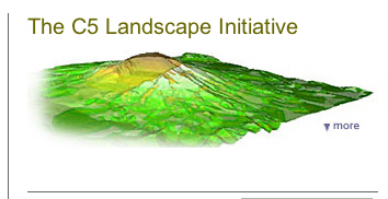
An exhibition of their work opens May 24, 2005, at sf Camerwork Gallery and The C5 Landscape Initiative is featured on the Whitney Artport in June.
I first commissioned C5's 16 Sessions in 1999, and have included a number of their projects in various exhibitions. Slayton is my co-conspirator in launching the biennial ZeroOne San Jose Global Festival of Art on the Edge in 2006. So I am no neutral observer, but never before have I participated directly in the planning and execution of a C5 project. For March and April 2005, I was an embedded reporter for C5's The Other Path campaign.
Willow Glenn, San Jose County, California, Thursday, March 24
C5 has met nearly every week for the past 6 years, usually at Slayton's home. When I arrive many of the members present have a glass of red wine, and I hope I haven't blown my embeddedness on the first day with the beer I bring. Everyone is surreptitiously eyeing the limited supply of crackers and cheese. Apparently, when Geri Wittig, one of the leads of the Other Path project, holds working group meetings, usually at someone's workplace, she brings full takeout dinner. But it is only in the presence of the embedded reporter that this is slyly broached. Slayton has been the teacher of almost every C5 member when they were in graduate school, and some boundaries can take a while to cross. It is 9:00 pm, and the meeting will last until nearly midnight after a full day on the job for most of the members of the group. They are discussing the upcoming hike of the other path of the Great Wall of China in northern California.
Slayton: Short path vs. long path. Need to discuss every time we take a detour. Doesn't make a difference. It's not like the Wall is going to appear. But you need to be looking in the right place.
Steve Durie [Speaking in phone conference falsetto to a C5 member in San Diego]: Is this Brett Stalbaum? This is Steve Durie. Do you know the secret handshake? Seven members here and an embedded reporter.
Slayton: Brett, we're all in agreement that we have a software solution to reposition the Wall into the California landscape, and we have ID'd the start and end point from the input data.
Stalbaum [in San Diego]: I've been thinking about this all day. Amul's algorithm should definitely identify the start and end points within the search area. The random virtual hiker algorithm looks for the closest distance between the two points and through a natural selection algorithm produces a track log, which can be loaded into the GPS.
Slayton: Sounds like the solution for the start and end points is achievable. The second part of the problem is how to traverse the terrain.
Stalbaum: Use the random virtual hiker.
Slayton: Then what is the relationship to the original data? Is that the strategy the group wants to move in or is there a different way to more closely align data?
Bruce Gardner: Easy thing to do would be to take north / east values.
Amul Goswamy: Why not do both?
Stalbaum: The simple method might put us into a terrain that's not traversable - and that's interesting. More like an archaeological investigation where you find an area that you might make a find in. Where it enters pure experimental art is going there and not being sure what will happen.
Matt Mays: It's like passing the common sense test. If I put the two paths together, and they don't look alike, then . . .
Gardner: To be honest with you, I don't want to go down that path.
Stalbaum: It's really easy to get lost with GPS.
In hindsight, it's remarkable how prescient this conversation was, but at the time my head was spinning. Short path. Long path. Other path. Standard deviation. Virtual hiker. Random hiker. Least resistance hiker. The Great Wall of China in California. What were they talking about?
The Problem of Big Data
Slayton did much of his graduate work at the Visible Language Workshop at MIT in the late 70s. In 1985 he founded the CADRE Laboratory for New Media at San Jose State University - one of the oldest new media art programs in the country. In 1998 he discussed with Durie that perhaps the most appropriate response to the dot com euphoria was to form an art company. Not just a company to sell it's members' art, but a collective that viewed business structures as important as - and as fertile as - network structures. After a "very involved process" with much time spent on a "first business plan, intellectual property issues and internal personal org documents" (Durie), C5 was formed.
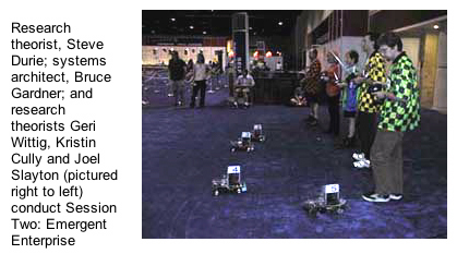
C5's first project was Radio Controlled Surveillance Probes (RCSP), which debuted at SIGGRAPH, the huge computer graphics trade show, in 1998 and was intended to demonstrate "the powerful combinitorics of theoretically devised surveillance strategies and heuristic data analysis leading towards emergent knowledge representation."
Characteristically, C5 thumbed its corporate nose at the conventions of the trade fair, and instead of setting up a booth in the very expensive real estate they had managed to wangle, they stood around in yellow checked racing shirts and biker shorts using remote control devices to send video cameras mounted on radio controlled cars around the floor. Other than the athletic wear, they looked more or less like any of the thousands of nerds attending SIGGRAPH playing with the latest electronic gadgets. Except they were spouting verbose speech acts about complexity, autopoiesis, ubiquity and adaptive learning, as if they were barkers for some Godardian carnival of theoretical excess. For only 25 cents, step behind the veil and you too can have the scales drop from your eyes and SEE the Emergent Enterprise caught in an Entailment Mesh! Truly it was the word made flesh, theory as product.
The performative aspect of a C5 project is critical to their hybrid practice. It is also a Trojan horse. Part of the goal of RCSP was to gather enough data to choke on; enough so that the body of data would be literally incomprehensible. Then C5 could run various analyses, without knowing any kind of answer in advance, to see if the amorphous body of data can take shape, so to speak, as some kind of data body. In other words, the goal was not, necessarily, to solve some real world problem about "human interaction in a public architectural environment," but recognition that there is "big data" in the world that materially affects us and inflects our behaviors, which we do not understand. RCSP gave C5 a big data set to play around with and explore. And as it turns out, it's a widespread problem. As Wittig says,
At Siggraph when our art approach to surveillance strategies and knowledge mining were of interest to both cancer researchers and intelligence agencies, we knew we'd found our world in these hybrid spaces.
Every C5 project since RCSP has dealt to some degree with this issue of big data. The C5 Landscape Initiative projects also do so but add the body into the equation more directly than in any other previous project. Stalbaum, I suspect, speaks for most members of C5 when he says:
We can experience the problem of big data not only through visualization (though this is an agenda of other C5 research), but very important to me, personally, is the ability to experience large GIS datasets with our feet, with packs on our backs. That is the performance layer. It is a pretty exciting space to experience data art.
It is certainly why the Landscape Initiative is the most accessible of C5's projects.
North From San jose, Friday, April 8
I drive up to the designated meeting point near Mount Shasta in Northern California with Slayton and C5 "Catalyst" Lisa Johanson, who is not a member of the core group, but she has been involved in all of The Analogous Landscape mountain climbs as the First Aid and Safety Officer. I have my doubts about this as she fell and broke her wrist on an earlier climb, but she is married to Slayton, so I keep my mouth shut.
During the 5 hour drive, I share the back seat with Sam, a year old chocolate Lab, and read various C5 texts on my computer, grilling Slayton about C5 and the Landscape Initiative. In a very real way, such conversations between C5 members are central to who they are and what they do. I learn that all projects begin with a so-called field mediation.
In 2001 Bruce Gardner, who is sort of like C5's Marshall Flinkman from Alias, cycled out to Alviso, an area of levies at the southern tip of the San Francisco Bay, and collected GPS coordinates at which C5 members were later instructed to rendezvous. They sat in a "Robert Smithson spiral" and read papers about landscape and data or performed various exercises such as location/perception tests. Out of this - and subsequent weekly meetings and research - the specific projects of the Landscape Initiative evolved.
We arrive at 11:59 pm, and I lose the bet about whether we will get there today or tomorrow, but only because at the end Slayton drives recklessly down residential streets. Competition is not an unknown element in the C5 psyche.
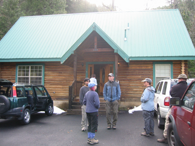
C5 Researchers
Most of C5 is already at the rented lodge where we are staying the night. We do introductions.
Geri Wittig is a pink-haired Tinkerbell who hiked the Chinese Great Wall of China for six weeks in the spring of 2004 to gather the GPS data for The Other Path. In conversation she has a kind of Terri Gross hitch that puts you off guard until it's too late and the trap is sprung; you are forced into admissions you would not normally offer up. Wittig is senior Web producer for Adobe and heads up The Other Path project.
Wispy-chinned Jack Toolin has the self-confident smirk of Steve McQueen in The Great Escape. His background is in performance and photography, and he is primary corporate documentarian. He rode his motorcycle 13,000 miles to document The Perfect View, one of The C5 Landscape Initiative projects about the nature of the contemporary sublime.
Amul Goswamy, an Apple Engineer/Scientist who joined C5 in late 2003, is introverted like an engineer - until the right topic comes up, like the role of elegance in code writing - and looks how you might imagine Fez from That '70s Show growing up into Matthew Barney. He is a vested Associate Partner and working with Stalbaum he found "a pattern of squares in the California landscape whose standard deviation of elevation matched those of the data points of the path of the Great Wall of China." He also created a software platform to match media objects with GPS coordinates based on time/date stamps.
Steve Durie is a self-described "upper-middle child in the current family of eight, who finds himself taking a negotiator's role at times and at times is one of several competing class clowns and playful players." He led development of the GUI being used to display data and media documentation in the sf Camerawork exhibition.
Later in the evening, Matt Mays arrives with Gardner. He has only been on board since November 2004, and this is his first Landscape Initiative event. He seems young enough to be almost any precocious kid in a movie about the future. Matthew Broderick in War Games. He is the acting Chief Legal Officer.
Bruce Gardner, besides his Alias persona, handles most of C5's sysadmin functions as well as acting as quartermaster for C5 gadgets.
Brett Stalbaum is camping with his wife Paula nearby. He reminds me of Radar from Mash, but the group thinks of him as former California governor and current Oakland mayor Jerry "Moonbeam" Brown. What everyone likes to say is that he is the designated meal, if things go really badly. Stalbaum developed various "hiker" algorithms to get from Point A to Point B, so if we don't make it, it is sort of his fault, I guess. It would be a pity though. His enthusiasm and knowledge is iinfectious.
Castle Crags, Shasta County, 9:30 am, Saturday, April 9
After a breakfast, we head over to the campground where Stalbaum is.
Wittig hiked the Great Wall of China in the spring of 2004, collecting GPS data along the way, and while it seems like a relatively straightforward matter, it has taken almost a year just to find the Wall's "other path" in California. Using a digital elevation map of California - with 2 billion data points - the task was to match the elevation of beginning and end points and the distance between them of each of eight segments of the Great Wall of China. As Stalbaum explains the collaborative and iterative process:
In the current great wall search, we use the stdev of one landscape (china) to look for a matching landscape (California) by finding the closest stdev. In the elevation data set, stdev in less a measure of uncertainty as much as it is character. The higher stdev goes, the rougher the terrain. So Amul's search finds similar topographic areas. It literally gets us in the right area! The virtual hikers and some other software I wrote find the start and end points within that area, and a track between them that is similar to Geri's input tracks in China.
The Mutianyu segment of the Wall, the one just outside Beijing that most tourists go to, in California turns out to be just off the Pacific Crest Trail, which passes nearby. The excitement of the C5 members is palpable.
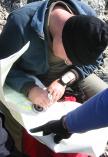
Stalbaum shows us two options on the map. We can drive to a part of the trail that is only about 2 kilometers from the start point or we can hike about 7 kilometers from the campground, "more like the C5 way."
C5 nominally is a very structured organization. Slayton is the President, every project has a lead, and the support roles, while fluid, are designated. Wittig and Stalbaum are the leads for The Other Path. But C5 is also an artist collective that relies on collaboration and cooperation, so getting a decision made can veer between iteratively procedural and simply going along with someone who is willing to take action. It takes a while but through a combination of acquiescence and naive optimism, we opt for the 7K approach.
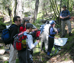
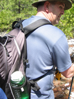
We drive up to a parking lot near the trailhead and Gardner pulls out a row of GPS devices, synchs them, and hands them out like the quartermaster he is. It is cool out and as others begin to put on warm hats and gloves, I realize how totally unprepared I am. I'm sure it will warm up pretty quickly, but I hope that Slayton and Johanson have some chow they will share with me. I have nada besides two quarts of water. Neither does anyone else it seems. Wittig did the original hike in less than a day, after all. How hard can it be?
We head out. It is a beautiful, sunny day. The trees are bare, and snow is on the ground. Paula thought she saw some snow flowers the day before. At first, everyone is looking at their GPS device constantly; worrying about losing satellite coverage. At every clearing, we all hold our GPS devices to the sky like fans at a Rolling Stones concert - or a Sprint ad.
Durie rigs a stick to dangle his GPS device over his shoulder, fishing the airwaves for satellite transmissions. After about an hour, people have begun to strip off their clothing, and we settle into a steady pace.
I ask Stalbaum about the route we will take once we reach the starting point. This was a big topic of discussion at the Thursday evening session I attended and has been for months. Basically, there are two options. From the start point, you can more or less ignore elevation changes and follow the compass directions of Wittig's original path. In other words, go 400 meters at 275 degrees, then go 500 meters at 250 degrees and so on. The problem is, of course, this could easily put you at the foot of a cliff - or over one. It might have you fording streams in awkward places or going through the middle of a dwelling. You never know.
The other option is to choose a route between the start and the finish that most closely matches the elevation points of Wittig's original path but ignores cardinal direction. Stalbaum has developed a number of algorithms, which he calls virtual hikers, to calculate this option. The particular algorithm he has used in this instance is the "slope reduction hiker," which basically sets a maximum limit for how steep the slope can be at any given point. The plan is to use this path on the outward journey and consider using the "directional" path on the return journey.
12:30 pm
After two hours people are not talking quite so much. It's 12:30, but we are only about halfway there. We still have 3.7 kilometers to go. We decide to press on and eat once we get there.
1:30 pm
After three hours, we are still three kilometers from the start point. The path to the other path is not very direct. It's 1:30 and people are starting to do the calculations in their heads. If we were there now, it would be three hours back, which only leaves about two hours to do the actual hike before it gets dark. And we're not there yet. Time for a snack.
2:30 pm
For the next hour, we seem to keep a constant distance from the start point. Essentially, we are circling it at a lower elevation, waiting to commence our bushwhacking climb up to it from the best possible point.
After four hours, we decide we have reached the best possible point to bushwhack to the start point. It parallels a stream, which the start point is next to. It's 2:30. Someone suggests that now that we know where the start point is, we should head back so we don't get caught in the dark and then return in the morning - via the shorter route. But we're only 500 meters away, let's give it a bit longer. "Making it" is a powerful undertow, pulling us up as much as anything we consciously decide at this point.
3:00 pm
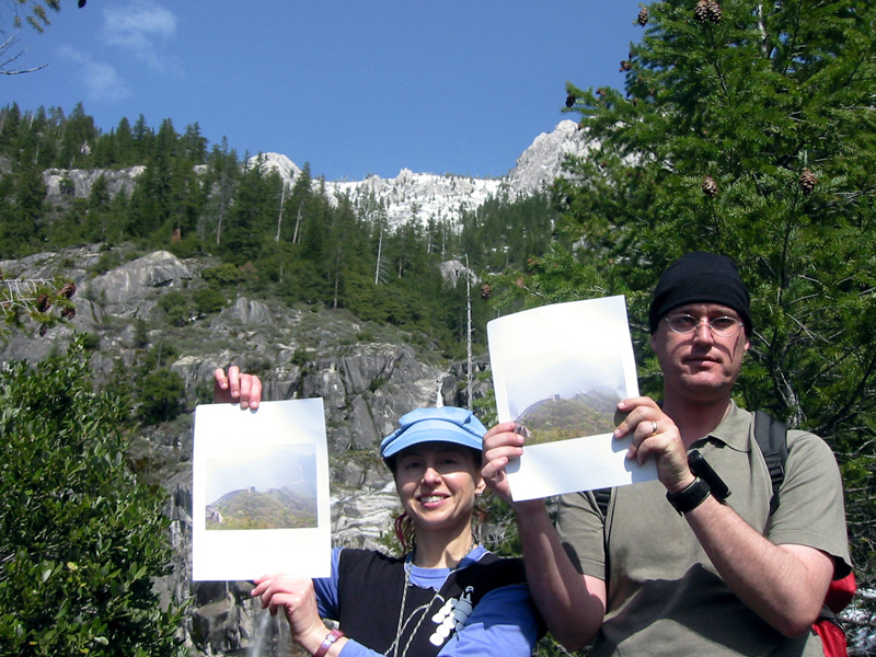
Up we climb. And up. We're only 350 meters away. It's slippery shale but at least no manzanita. Then there is manzanita. Gardner, who bikes competitively, runs on ahead like a gazelle. At 3:00, we're only 330 meters away. Learned discussions about being within the margin of error of the GPS calculations begin in jest at first, but with increasing seriousness. We stop. We get out photographs of the Wall in China and hold them up to the landscape. Looks pretty good.
Then a barely audible "I see it!" is heard from Slayton, who has gone on ahead. We decide to give ourselves till 3:30 and keep going. At 3:30 we're within 300 meters. We can definitely see the ridge that the other path would traverse. We're definitely within the margin of error now. We're definitely tired. It's definitely getting late.
The plan had been to do a field mediation at the end of the trip, but there is no time for that. We seal an army surplus ammo box with wax. Inside is a flash drive with texts by C5 about The Other Path and The C5 Landscape Initiative, which we leave behind as a kind of "theory cache" for thirsting future hikers, intentional or otherwise, of the Great Wall of China in California. Everyone documents the documents cache.
We eat lots of chocolate and head down. Significant amount of time is spent on our butts. Even Sam, the Lab pup, chickens out at one point, and Slayton has to climb back up after him and push him over an edge to get him to come down.
5:00 pm
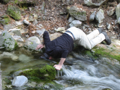
Eventually, about 5:00 we reach the trail. Gardner dunks his head in the river and gets a Mr. Misty headache. The rest of us just want to get going. We take the "short" route return, figuring that walking on the road in the dark will be better than walking along the trail. We make it to a parking lot, and Gardner and Toolin are sent on ahead to get a car to pick us up. At least that's the plan. By chance, someone with a pickup is finishing his walk and offers to drive us all to our cars. No hesitation. Yes! Thanks. Driving along, exhausted but happy, it's hard to imagine what it would have been like to walk the remaining 3 miles, even if on tarmac. We tumble out of the pickup and into our cars and immediately head into town for some food.
Field Mediation, Dunsmuir Lodge, 10:00 pm, Saturday, April 9
After dinner, after a couple of beers, we're back in the lodge. Everyone is dog-tired, including the dog, but they decide to hold their field mediation. The group reads papers, which are philosophical discussions of big data and the sublime and the short path versus the long path. They are provocative and provide context for what we have done - which is the intent. There is supportive but probing discussion of each paper. To me, it's a remarkable testament that we have just done something much more than a hike. I quote briefly from each.
Stalbaum reads Field mediation text, Great Wall Mutainyu Trek.
Interpretively, we may extract from all of this that the pursuit of information is the pursuit of the beautiful and that the pursuit of data - such as the limitless quantities now being produced by the big data disciplines of the earth sciences, astronomy, and biology - is the pursuit of the sublime. Information, which by definition must be processed from data, shows the symmetry, proportion, and congruity that can be found in a data set. Beauty tells us something with clarity and a certain force, it leads to knowledge. Data, by contrast is the less visible representational form that controls ever more of our existence today; it is large and overwhelming to the senses, and we are entailed by it. The former implies a resting point for understanding as moments of clarity and truth, the later implies an impulse for exploration and new data collection, an always moving desire to stir things up and create new problems to face. How artists implement their forms of expression between information and data, and the transitory positions between them as they transform in infinite recursion, is the aesthetic issue of our time. Data processed into information raises questions that lead recursively to more data collection and processing. The cycle of the differentiation and dedifferentiation, beauty and sublime, information and data, and even Deleuze and Guattari's concepts of territorialized and deterritorialized, represent a framework in which to engage with data as expansion toward the sublime.
Toolin reads The Paradox of Indeterminacy in the Age of Reason, picking up the theme of the sublime and applying it to The Perfect View project.
Indeterminacy is a central feature in the Perfect View. For myself who made the cross-country trek via a route that was determined by others, being therefore inherently filled with the unknown. (Talking with some of the site contributors about their Geocache explorations, I noted that this same element of adventure, seeing someplace for the first time, was one of their main motivations. And for Perfect View as an artwork: it aggravates the conventions of art. While using traditional photography to document and exhibit the sublime sites, Perfect View is a monumental, performative land art piece that required the collaboration of heretofore strangers.
Wittig reads Prepared chance: data driven landscape exploration and leaves us with the "moral" of the trip.
These types of big data generation with the goal of finding meaningful data signals in the chaos through relational processing have a long tradition in the C5 approach to discovery. With C5_s explorations of defining the Other Path, which entail processes derived from taking originating data from remote space-time events and transposing them onto large data sets and ultimately generating corollary space-time events, perhaps the inversion of Pasteur might even be taken to another logical conclusion: the mind favors prepared chance.
Mays reads Dimensionality in Locative Media,
In 'The User Illusion,' the Danish writer Tor Norretranders discusses the bias towards the straight line in modern Western civilization. The straight and deterministic path contains less information than the meander of nature. "A raindrop's path down a mountain is very difficult to describe." Traversing the Other Path does not yield a straight line. Instead, walking down the path we can turn left or right if the virtual and actual path affords it. Accepting or resisting the path generates information.
Around 11;59 pm, Slayton closes with his thoughts on Semantic Segmentation: Short paths/long paths.
In the midst of real definitions, we continual seek something definite. Where are we? How do I get there from here? Inevitably the answer lies in a precessions of relations that provides an acceptable definition to the problem at hand. Determining what leads to what is the demeanor of the short path, every point/line an analogy of not only the previous point/line but all segments of which it is a class. As a segment the short path is like a paragraph in a great run on sentence. Go here, go there, go around that, go back.. move, stop, start, faster, slower. Similar to a Turing machine this embedded potential behavior of the path and its potential for scaling of the event exists within universal formal system of inflections, a path grammar.
Shortly after midnight, physically and intellectually exhausted, we turn in.
The Path More Or Less Taken
Robert Frost's famous poem, The Road Not Taken, is primarily remembered for its declaration of an alternative autonomy.
Two roads diverged in a wood, and I--
I took the one less traveled by,
This could equally be said of the route C5 has taken over the past eight years, since its inception. And yet the poem is also the story of a binary logic. Of either/or.
Two roads diverged in a yellow wood,
And sorry I could not travel both
The C5 Landscape Initiative is about both/and. It is about using one experience to generate an other, analogous, one. "It is unexplored terrain, and exploration has always been its own justification." (Stalbaum)
Minneapolis, Monday, April 11
It is only on Monday, when the data we have returned with are preliminarily analyzed, that we truly comprehend that 7K is how the crow flies. Walking along the switchbacks of the mountain made it 14K traveled, which does not include an additional 10 kilometers of just going up and down - 10K of elevation change over the course of the hike. No wonder my legs are tired. It's not every day you get to hike the Great Wall of China.
Wittig informs me that there will be another attempt at "Mutianyu Other Path virtual hiker trek." But while there was a kind of "summit-itis" at the end of our day, a real desire to make it to the exact start point, there is also an experienced acceptance of the day's events. We have more or less traveled the other path of the Great Wall of China. It was an experiment and now there are a lot more data to be crunched. Another experiment will be formulated. It is enough. It is good.
I want to thank all the members of C5 for their generosity and their openness in allowing me to embed with them. All quotations are from the C5 website and conversations and e-mail correspondence with individual members during March and April 2005.
 Most of C5 is already at the rented lodge where we are staying the night. We do introductions.
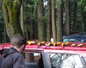 We drive up to a parking lot near the trailhead and Gardner pulls out a row of GPS devices, synchs them, and hands them out like the quartermaster he is. It is cool out and as others begin to put on warm hats and gloves, I realize how totally unprepared I am. I'm sure it will warm up pretty quickly, but I hope that Slayton and Johanson have some chow they will share with me. I have nada besides two quarts of water. Neither does anyone else it seems. Wittig did the original hike in less than a day, after all. How hard can it be?
 Durie rigs a stick to dangle his GPS device over his shoulder, fishing the airwaves for satellite transmissions. After about an hour, people have begun to strip off their clothing, and we settle into a steady pace.