Mapping the Urban Homunculus
Steve Dietz
in ELSE/WHERE: MAPPING
on the mapping of network and cartographic space
co-edited by Janet Abrams and Peter Hall
Design Institute, University of Minnesota, 2006
"If after the death of God (Nietzsche), the end of grand Narratives of Enlightenment (Lyotard) and the arrival of the Web (Tim Berners-Lee) the world appears to us as an endless and unstructured collection of images, texts, and other data records, it is only appropriate that we will be moved to model it as a database. But it is also appropriate that we would want to develop poetics, aesthetics and ethics of this database." Lev Manovich
From the death of God to the rise of the Matrix is a lot of territory to cover, and from time immemorial, one of the commonest ways to place ourselves in relation to the vast is the map. In the age of vast information overload, the map has become a favorite interface to data sets of all types, geographic and otherwise. More importantly, the map interface becomes a kind of visual bridge between disparate facts - zip codes and cereal preferences, for instance. As location-aware devices proliferate, maps will become an increasingly important means to theorize and discover relationships that are not easily graspable. Jamie King writes elsewhere in this volume about the insidious effects of such "total information awareness," which are undeniable. Nevertheless, it is at least as important to imaginatively develop counter strategies, often based on the "useless arts" of poetics, aesthetics, and ethics, as it is to remain skeptical.
Several artist-based projects model how maps might help not only locate us, but how mapmaking can be a tool to build a counter-image of our future urbanity that contrasts with contemporary culture's panoptic, data-mining gaze of our zipcoded profiles. In this regard, the image/idea of the homunculus is a useful metaphor for two key ideas: What we experience physically or personally has a disproportionate effect on our mental maps of the world and simple rules can give rise to complex - even "intelligent" - systems.
Mapping the Homunculus
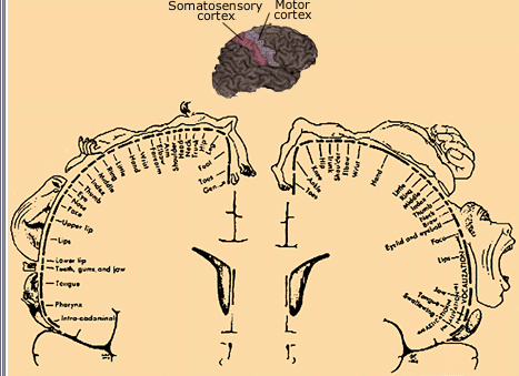
Figure 1 Wilder Penfield.
These famous brain maps from the 1930s by Wilder Penfield show that each part of the body is represented on two strips of the brain's cerebral cortex, the somatosensory cortex (left), which receives sensations of touch, and the motor cortex (right), which receives control movements. Fingers, mouth, and other sensitive areas take up most space on both maps. Penfield called these cross sections the "sensory homunculus" and the "motor homunculus."
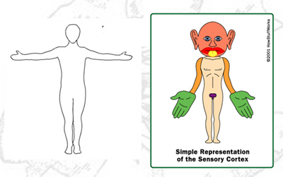
Figure 2 Homunculus (right)
The neurophysiology isolated by Penfield means that if what is on the left in Figure 2 is a conventional "map" of the human body based on what we see, on the right is a map based on what or where we feel the most. If we extend this notion to mapping our direct experience of the lived environment, it will create a very different image from a conventional street plan.
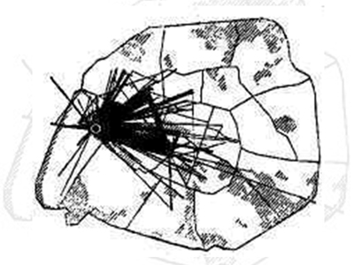
Figure 3 Chombart de Lauwe
In "Theory of the Derive," Guy Debord quotes the 19th century sociologist Chombart de Lauwe:
"an urban neighborhood is determined not only by geographical and economic factors, but also by the image that its inhabitants and those of other neighborhoods have of it."
Figure 3 is of a map by de Lauwe of all the movements made during one year by a student living in the 16th Arrondissement of Paris. Her itinerary forms a small triangle with no significant deviations, the three apexes of which are the School of Political Sciences, her residence and that of her piano teacher, illustrating, according to de Lauwe, "the narrowness of the real Paris in which each individual lives" and which, according to Debord, ought to provoke "outrage at the fact that anyone's life can be so pathetically limited."
Regardless of what one may think of the student's life - and probably many of us can relate to a dominating triangle of home, work, and hobby at various points in our lives - metaphorically speaking, de Lauwe's mapping of the student's movements in Paris is her geographic homunculus.
A contemporary version of de Lauwe's project is the Waag Society's Amsterdam Real Time project where participants were offered "tracer-units" - modified PDAs - that tracked their movements through Amsterdam, capturing in real time individuals' routes as trace patterns. These traces were collated and reproduced on a map of Amsterdam - with all the geographic information removed - leaving only the ghostly traces of hundreds of routes via all manner of transportation throughout the city. The issue with such homuncular maps is that individually they don't create a rich image of the whole city. However, with new understanding of complexity and emergent systems, it is possible to imagine that when these "simple" views are combined, the sum may be greater than the parts, and perhaps the map will be the legend to a more complex system that was not previously understood.
The Homunculus in the Machine
In fact, a second meaning of homunculus comes from philosophical debates about the nature of consciousness. Descartes used the notion of the Cartesian Theater as a metaphor for a kind of control room of the central nervous system. The homunculus operates this Cartesian Theater like a wizard of Oz, assembling all the disparate data received by the sense into a whole - in other words, what we understand to be consciousness. The problem with this scenario is that such a homunculus would appear to have to have consciousness himself, which does not resolve the issue of what consciousness is. In the past, a strategy of theorizing a number of homunculi who work for the main homunculus just led to an infinite regress. The philosopher Daniel C. Dennett, however, has argued that
"The only idea anyone has ever had which demonstrably does get rid of the middleman is the idea of computers. Homunculi are now O.K., because we know how to discharge them. We know how to take a homunculus and break it down into smaller and smaller homunculi, eventually getting down to a homunculus that you can easily replace with a machine. We've opened up a huge space of designs - not just von Neumannesque, old-fashioned computer designs but the designs of artificial life, the massively parallel designs."
In other words, whether or not one believes that beyond a certain point complexity becomes consciousness or autonomous intelligence, it is now commonly accepted that simple rules can lead to complex systems, and I am suggesting that homuncular maps, deeply rooted in the personal, can nevertheless give rise to very powerful and useful maps of more complex systems such as cities. It then seems possible - and if well designed, even desirable - to imagine societal systems that rely on individual input to generate emergent and dynamically adaptive solutions independent of a pre-existing structure, a single leader or not-easy-to-effect top-down process. Projects such as those described below are at least sketches that help us toward a poetics, aesthetics and ethics of the possibilities of a counter-practice to total information awareness.
Maps Matter
It may be overstating the obvious, but one of the reasons to focus on maps is that they matter. They make a difference in society's somatosensory cortex as profound and direct as contact has on our own.
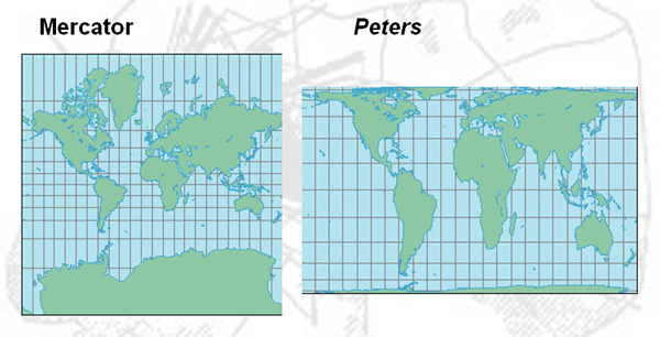
Figure 4 Mercator Projection (left); Peters World Map
Although we have come to accept it as commonplace, creating abstractions of the physical world is no mean feat. In 1569, when Mercator created a 2D projection of the world (figure 4, left), it was an almost magical event. More importantly, for the first time it provided a synoptic image of the world, which has dominated ever since. More than 400 years later, in 1974, the cartographer Arno Peters created a new projection, which accurately portrays the size of all nations, in contrast to the Mercator map, which accurately depicts the shape of landmasses, but severely enlarges the size of landmasses nearer the poles - primarily Europe and North America.
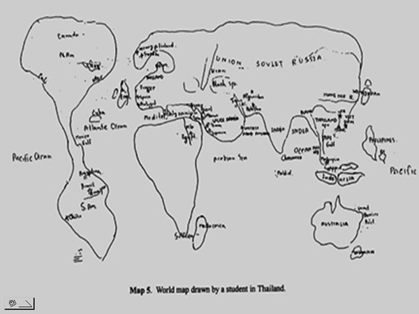
Figure 5 Thomas Saarinen. Thailand, "Children's Mental Maps of the World"
Peters felt he was giving a voice to underrepresented countries in the developing world. Arguably an important issue, especially given the research by Thomas Saarinen, who gathered over 3,800 sketch maps of the world by children from 49 countries for the project "Children's Mental Maps of World." A composite of the results by children from Thailand looks most like the Mercator projection, which greatly exaggerates areas where the children don't live. Theirs is not a homuncular view of the world, and regardless of how one feels about the politics behind each image of the world, they have impact.
Part of the significance of the Peters projection is not only the interface it actually provides, but also how it functions to highlight that the dominant Mercator worldview is only one option. It is not the only way and certainly not the "natural" way to map the world, no matter how logical or efficient. The significance of each of the following projects is not only their homuncular viewpoint; it is how they de-naturalize the dominant interfaces we swim in, whether it is Sky News or America Online or Mapquest. What is potentially more powerful than the meanings of the data visualized is how the visualization instantiates - or disrupts - systems of knowledge and relationships of power. As the geographer Denis Wood frames it, "maps work by serving interests." These projects serve the interests of individuals and local communities while still attempting a holistic functionality; they disrupt business as usual in terms of who and what is represented; and many of them provide alternative interfaces that viscerally connote the possibility of alternative viewpoints and multiple worldviews.
Minneapolis and St. Paul Are East African Cities
In 2002, the artist
Julie Mehretu
was invited to do a residency at the Walker Art Center in Minneapolis. As she tells it, she was quite surprised in this land of lutefisk and lefse to get into a heated conversation with her airport taxi driver about current events in Ethiopia - where they were both born. On further investigation, it turned out that the largest Somali population outside of Africa lives in the Twin Cities and that a significantly growing number of residents are from East Africa by birth or heritage.
Mehretu decided to work with about 30 students from 2 local high schools, all of whom were of East African descent. They were asked to complete two projects. She writes about one of them, "Map of My Life/Sounds of My World":
There are all kinds of official maps that tell us what country, state, city or town we live in. In a way, the maps we use define who we are. Since political power and identity are tied to maps there has been much conflict over borders, maps, and place names.
The exercise the students were asked to do was to photograph sites that mattered to each student and make a brief audio recording of the significance of the image and locate where it was taken on a map of the Twin Cities.
The tools for these projects were decidedly low tech - a map of the Twin Cities, a notebook, and inexpensive digital cameras and recorders. Once the students were done recording their stories, the texts, images, sound recordings, and map locations were entered into a database and the Belgium-based group Entropy8zuper! (Auriea Harvey and Michael Samyn) was commissioned to design a combinatory map interface.
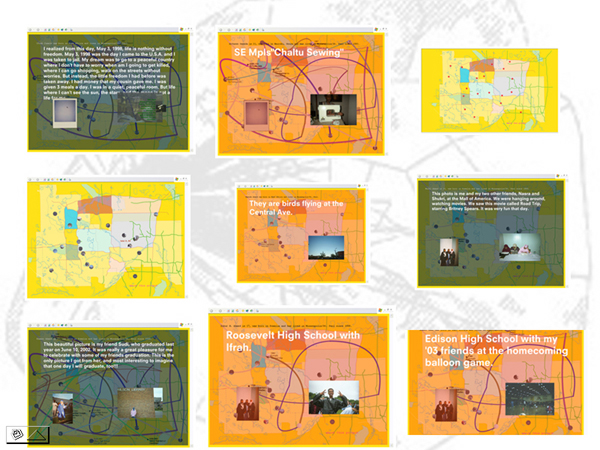
Figure 6 Screenshots. Julie Mehretu and Entropy8Zuper! Minneapolis and St. Paul Are East African Cities. 2003.
The interface is an interactive audio-visual collage composed of the sound bites and photographs contributed by the students. You can "follow" the stories of each participant by clicking on nodes, and as you move from spot to spot, you leave a trace, which cumulatively maps your route through the interface - through the content. The nodes are not mapped to their geographic coordinates; they provide an impressionistic re-mapping of the city based on each participant's selections and commentary. These are the receptors in the cities to which the participants were particularly sensitive. In addition, the interface references Mehretu's own paintings, which consist of a series of highly specific mappings painted over with the vectors of explosive interactions.
Citizen Sketch Maps
One of the criticisms that can be leveled at the homuncular viewpoint is precisely that one ends up with a mishmash without order. Perhaps this is why Kevin Lynch, the city planner whose influential book Image of the City first popularized the idea of using maps sketched by individuals "in order to communicate, study, and exploit personal cities . . . didn't publish a single one of the maps he collected . . . preferring to 'summarize' them in maps of his own devising."
This tension between instrumental professionalism and the homuncular perspective is not limited to city planning by any means. Roy Rosenzweig, co-author of the important book Presence of the Past, which examines, as one reviewer puts it, "how deeply ordinary people are engaged with the past but at the same time are alienated from the history they have been taught," writes about this issue:
"Our survey respondents often used the past in complex and subtle ways, but their approach was sometimes in tension with my historical training and preferences. For example, I found their emphasis on the firsthand, the experiential, the intimate, and the familial to be confining as well as illuminating. At times respondents seemed primarily concerned with their own and their family's pasts; the stories of others were often ignored. This privatized version of the past, I worried, can reinforce rather than break down barriers between people, resist rather than promote change."
Indeed, while many of the 30 participants in Minneapolis and St. Paul Are East African Cities reported that participating in the workshops was a transformative experience, its value to viewer-participants may be in direct proportion to their own histories - their homuncular geographies - that they bring to their viewing. Is there a way to create a wider base of experience without becoming prescriptive; to honor the individual point of view while ending up with an overall point of view that has value for more than the participants?
The Communicity
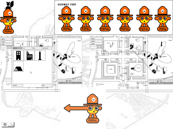
PDPal, a mobile, public map art project by Scott Paterson, Marina Zurkow, and Julian Bleecker pursues the notion of a "communicity" - a city written by individuals and filtered by individuals to create alternative cartographies, both physical and emotional, which would never be found on Mapquest, yet which collaboratively map the homunculus of a city.
According to the artists, part of the inspiration for PDPal was entirely personal, almost nostalgic.
"When we were little, we really wanted a little companion who would ride sidesaddle on the crests of our ears. A mischievous and constant pal, who was our charge and also our commentator, who gave context and breadth to the world and shook up our autonomic ways."
PDPal is designed as a new way for users to share their experiences of experience and learn about others experiences of, currently, the Minneapolis Sculpture Garden, the Twin Cities, and Times Square in New York. PDPal is a mapping application for the Palm-based PDAs and the Web, which transforms everyday activities and urban experiences into a dynamic city that the user creates, composed of the places she lives, plays, and works - shades of de Lauwe - as well as those she remembers. PDPal allows the user to capture and visualize these places and imaginatively capture the meanings and histories of these places so they, in effect, write their own city.
What is particularly successful about PDPal, is its use of a graphically friendly character known as the Urban Park Ranger to nudge users to think about their maps as narratives as much as cartography. Maps tell stories and that is at the heart of PDPal. What is perhaps less successful is that even though it is designed as a platform for mobile devices, the restrictions of the format make it a less enjoyable experience in the field for entries, and unlike a project like Urban Tapestries (see below), there is little advantage to viewing other people's maps in the field. Gathered around the campfire screen is definitely the best way to listen to the tales elicited by the Urban Park Ranger.
On your PDA - or the Web - you're able to input locales and routes on a traditional street-based map of the area. You then input your city, identifying those places and pathways that are individual to your urban experiences. The Urban Park Ranger, a character designed as both an embodied software Help function as well as a provocateur, acts as a guide in the process of creatively seeing your city in new ways by presenting you with simple leading questions such as "What is noisier, Godzilla or a garbage truck? Map the beasts that roam your city."
PDPal is also a new kind of virtual public art practice, bridging the physical and the virtual, the cartographic grid and psychogeography, the personal and the community, according to Scott Paterson.
"I tend to think of the term 'public' as a spatio/temporal phenomenon. It concerns the experience of collectively constructing zones where we act out roles as citizens of that public. PDPal is a public art project because it provides two platforms that support the collective construction of these citizen zones. Inspired by psychogeography, cognitive mapping and Hakim Bey's temporary autonomous zones, PDPal investigates methods of construction via dimensions beyond the latitude and longitude of geographic mapping such as time, memory and emotion. PDPal exists as a public art project in that it considers mobile devices and the web as a constantly shifting ephemeral public space generated by the expressions of its population of users - a place we call the 'communicity'."
Another significant aspect of PDPal relates to the fact that all maps represent interests. Similarly, all interfaces, no matter how neutral seeming, have an embedded philosophy. To counter this or at least make it apparent, PDPal foregrounds its interface through the intervention of the Urban Park Ranger.
"Every project has a voice or bias. It's the artist's prerogative to make this voice explicit or implicit. Much software-as-art work being done today has an implicit voice in that the protocols are inherent in the interaction, which is not readily apparent because the project is seen as enabling action rather than limiting it. The UPR on the contrary acts as a provocateur as well as a host to explain the particular bias of the software and in doing so, to inform the user of our critique of more traditional mapping techniques."
When you log onto the PDPal website, your city or personal map is displayed, and it can also be visualized alongside the cities of other PDPal users and, eventually, filtered according to various criteria - the ratings and attributes entered when making a map. You can connect with other users whose home places are near yours in order to see how they imagine the neighborhood you both share, in effect, or filter the maps by keywords used when entering data, creating what the artists refer to as a "communicity" out of everyone's personal city, without losing access to the personal and the individual. With this communicity aspect, everyone's individual maps can be combined and recombined. PDPal image-maps the city without the intervention of authority. The map(s) are both individual and algorithmically collaborative. Nevertheless, in building the communicity, PDPal promotes an intensely personal response and homuncular point of view as the building blocks, so to speak, of the communicity.
Open systems need to take on a life of their own - to emerge - if they are to be truly successful. During the launch and promotion of PDPal, it received significant use, but it is unclear whether the narratives being told are enough to keep the communicity growing. However, each iteration of the project has made enormous conceptual leaps and adjustments, and particularly as the ability to add any base geographic map into the system is enabled, PDPal has the potential to be a virtual locus for homuncular storytelling.
Distributed Homunculi
While PDPal is designed to be accessible on any mobile device running Palm OS, the artists also specifically wanted to get away from the Cartesian coordinate system and encourage users to think more abstractly and imaginatively about the city. As such, the project is not dependent on location-aware devices. Users can enter information in the field, but in fact many do so from home, based on their knowledge and memories of an area, and certainly most viewing is done on a computer, not a mobile device. There are a number of current projects, however, that are investigating personal mapping, but which require the viewer-participant to be at the location of the story to access it. In effect, the city is the map, or perhaps more accurately a telecommunications layer is overlaid on the physical city at a 1:1 scale. A user can "leave" a story about a particular location at that location. When another user walks by, her location-aware device can alert her to the presence of the story, which she may decide to listen to while strolling about the location.
One of the core principles of the Geograffiti project by Marc Tuters and Karlis Kalnis co-produced by the Banff New Media Institute is an open source philosophy. As they write:
"Recently, researchers and free-GIS enthusiasts have begun to share their data in a variety of networking machine-searchable environments enabling the development of a non-proprietary data pool of human geography, where meaning emerges and is inscribed at ground level."
GPS devices have the notion of a waypoint, which marks a particular spot. Generally, these are personal and not shared, but part of Geografitti is an open database, GPSter, of waypoints - or GPS-encoded locations where someone has left a "story" - writing, audio, video or some combination. Geograffiti is as much a platform for the exchange of geographically-tagged information as a particular interface like PDPal, but its goal is to enable "collaborative cartography . . . to map according to our desires; providing artists with tools with which to, effectively, step outside of the box, whereby architectonic space now becomes their canvas." In other words, it is a platform for mapping the urban homunculus.
Another project, Urban Tapestries, just finished prototype trials in December 2003. Like Geograffiti its use is location dependent, and it emphasizes an open authoring environment that allows any user to image his own version of the city. Again, as different stories "pile up" at specific locations, there comes to be a kind of community memory dispersed throughout the city. How this system will scale once there is a critical mass of participation remains to be determined, but judging from some of the "threads" created in the first two weeks of the project, excerpted below, the promise of an open source authoring system for mapping the urban homunculus is clear and tantalizing.
The jogger's challenge - street directions for adventurous running
Now you can see me (NYCSM) - a hide and seek game
Banks to pilfer - a security audit and plan of attack
A day in the life of an urban knitter
Lookalikes - urban spotting of celebrity lookalikes
Chocolate with that - a fictional journey
Clothes - what people are wearing
Strange shops - what they sell and the people that run them
Cool cafes and camera shops - a guide to the best macchiato and digital deals
Panoptic and Homuncular Visions
The future of computing is ubiquitous, aware, embedded and distributed. Increasingly, computers and devices such as RFID tags that communicate with computers will be embedded in objects throughout our environment. These skeins of computing can and almost certainly will give rise to nightmare scenarios of Total Information Awareness by governmental, commercial, and illegal powers. At the same time, especially if we can maintain a system of protocols that is predominantly open, these capabilities can be used to give expression to personal points of view, which, in turn, can be mapped into collaborative, alternative visions to TIA. These will not be sufficient actions, but they are important, if we are to approach the "lines of flight" necessary to imagine an alternative ending to our urban condition.